Blog > Overcoming Bali's Congestion Crisis
David Herse | December 13, 2025
Overcoming Congestion in Bali through Coastal Water Taxi Networks
Bali’s tourism recovery has overwhelmed its road infrastructure. With 6.33 million international arrivals in 2024—a 20% increase from the previous year—approximately 1,900–2,700 visitors travel from Ngurah Rai International Airport to Sanur daily.
The result: peak-period road travel now exceeds 60 minutes for a 15–20 km journey, with extended taxi queues adding further delays. Local residents face extended daily commutes, businesses experience delivery delays, and the quality of life for communities along the corridor continues to degrade.
Our Analysis
Mapulus conducted a preliminary feasibility study evaluating small water taxis as an alternative to road transport. Our analysis consolidated three assessments:
- Airport–Sanur water route feasibility via Benoa Harbour
- Comparative analysis of small water taxis versus large ferries
- Proximity analysis of a distributed coastal landing network for intra-Sanur travel
Using spatial analytics, we modelled travel times, mapped points of interest relative to the coastline, and evaluated infrastructure requirements for different vessel types.
Key Findings
| Mode | Distance | Travel Time (Peak) |
|---|---|---|
| Private Car | 15–20 km | 45–60+ min (plus waiting) |
| Small Water Taxi | 15–18 km | 25–40 min (including shuttle) |
Water taxis can complete airport–Sanur journeys in 25–35 minutes, compared to 45–60+ minutes by road—a time savings of 25–50%.
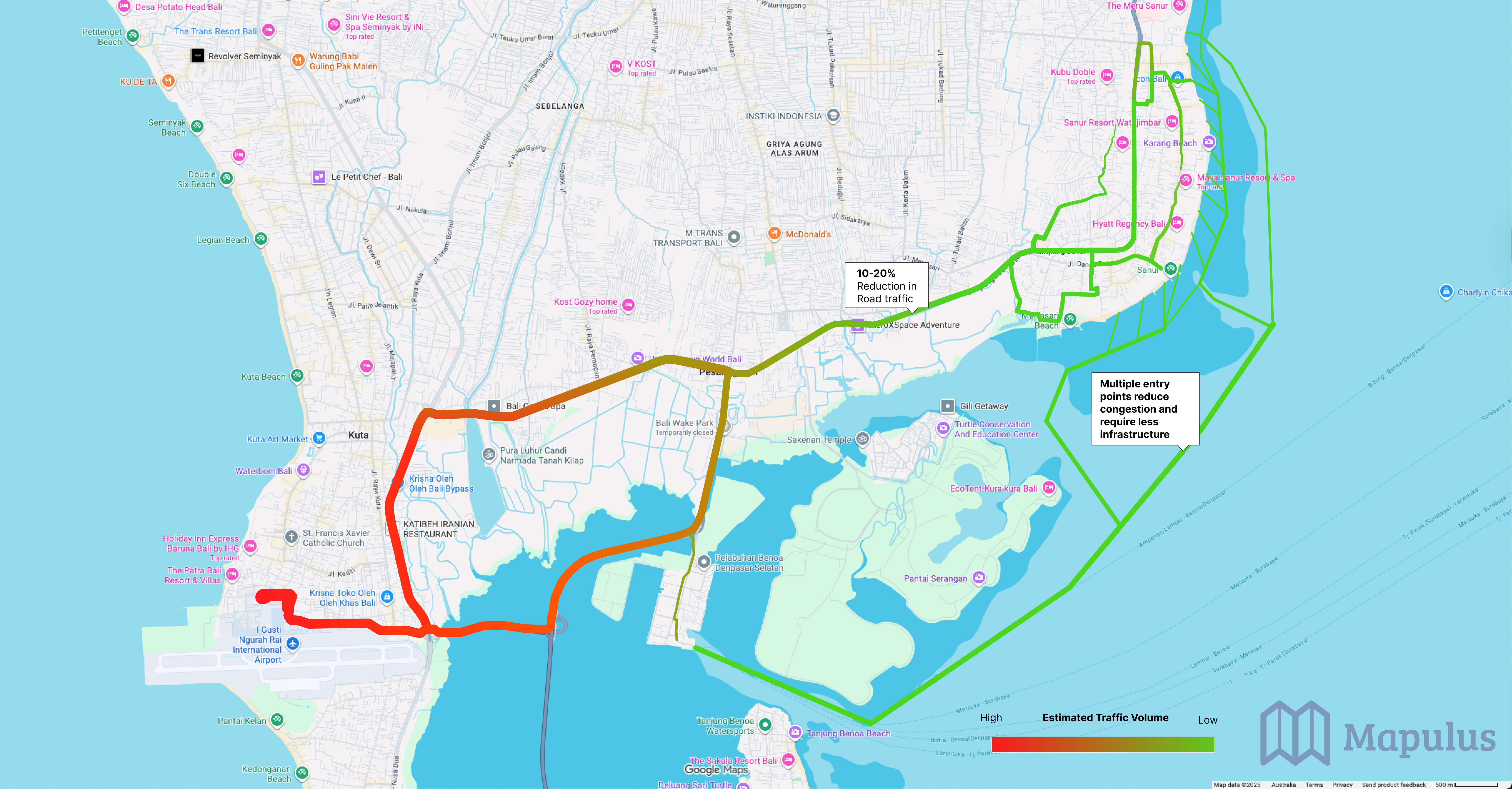
A 10–20% mode shift of airport–Sanur passengers could remove approximately 500–700 vehicles daily from the Bypass Ngurah Rai corridor. More significantly, our proximity analysis revealed that 60% of hospitality venues and 66% of retail locations sit within 350m of the beach, supporting a distributed network of beach landing points rather than centralised terminals.
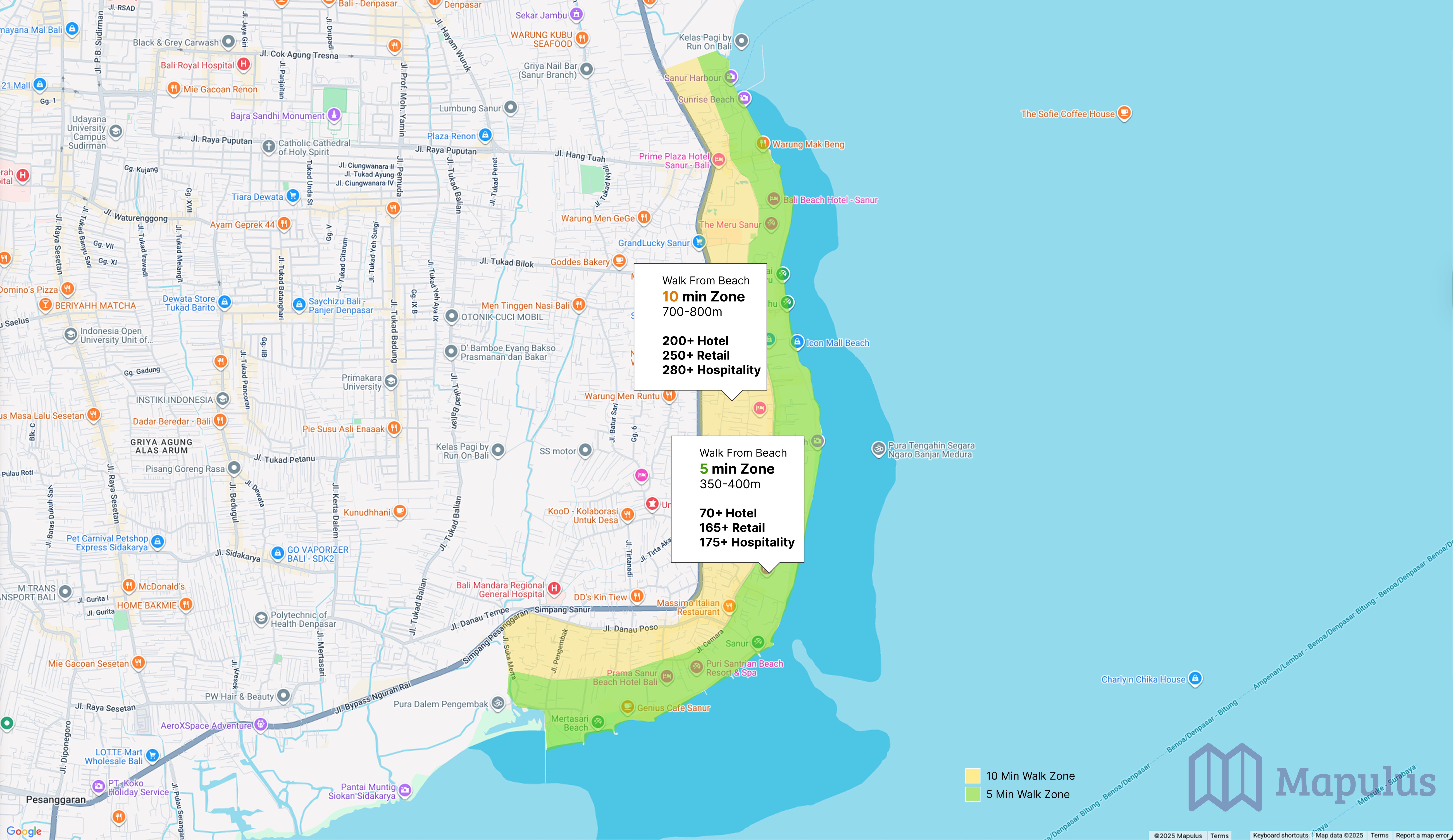 Most hotels, restaurants, and retail destinations east of Jl. Bypass Ngurah Rai are reachable within 350–800 metres of the coastline, supporting a decentralised water taxi landing model.
Small water taxis (6–12 passengers) offer operational advantages over large ferries: minimal infrastructure requirements, on-demand service with 10–15 minute response times, and incremental scalability—one vessel at a time.
The Data Gap
Current estimates rely on modelling and comparative case studies. To validate these projections and guide network design, we recommend deploying a passive sensor network to:
- Quantify actual travel patterns and modal shift potential
- Identify optimal landing locations and service frequency
- Collect data across seasonal variation (high, shoulder, and low seasons)
This empirical validation would provide government planners and private operators with the technical evidence needed to justify investment, secure permits, and achieve commercial viability.
Download the Full Report
Our complete preliminary report includes detailed travel time calculations, proximity analysis tables, infrastructure comparisons, and a recommended implementation framework covering regulatory compliance, risk assessment, and business model development.
Get the Full Report
Mapulus provides spatial analytics, movement sensor deployment, and feasibility studies for transport infrastructure planning. Contact us to discuss similar projects in your region.