Mapulus Help Centre
- Support >
- Territory and Boundary Identification in Mapulus
Territory and Boundary Identification in Mapulus
Effortlessly search for an address and learn about its encompassing boundaries within Mapulus.
Mapulus combines the ease of searching for any location with the ability to understand its relationship with your custom boundaries. You can quickly identify and view detailed information about the boundaries surrounding any address or location. Check out the Boundary Overlay guide to learn how to set up custom boundaries and territories. Follow this guide to search for an address and visualise the boundaries concerning a temporary point on your Mapulus map.
Searching for an Address to Find Boundaries
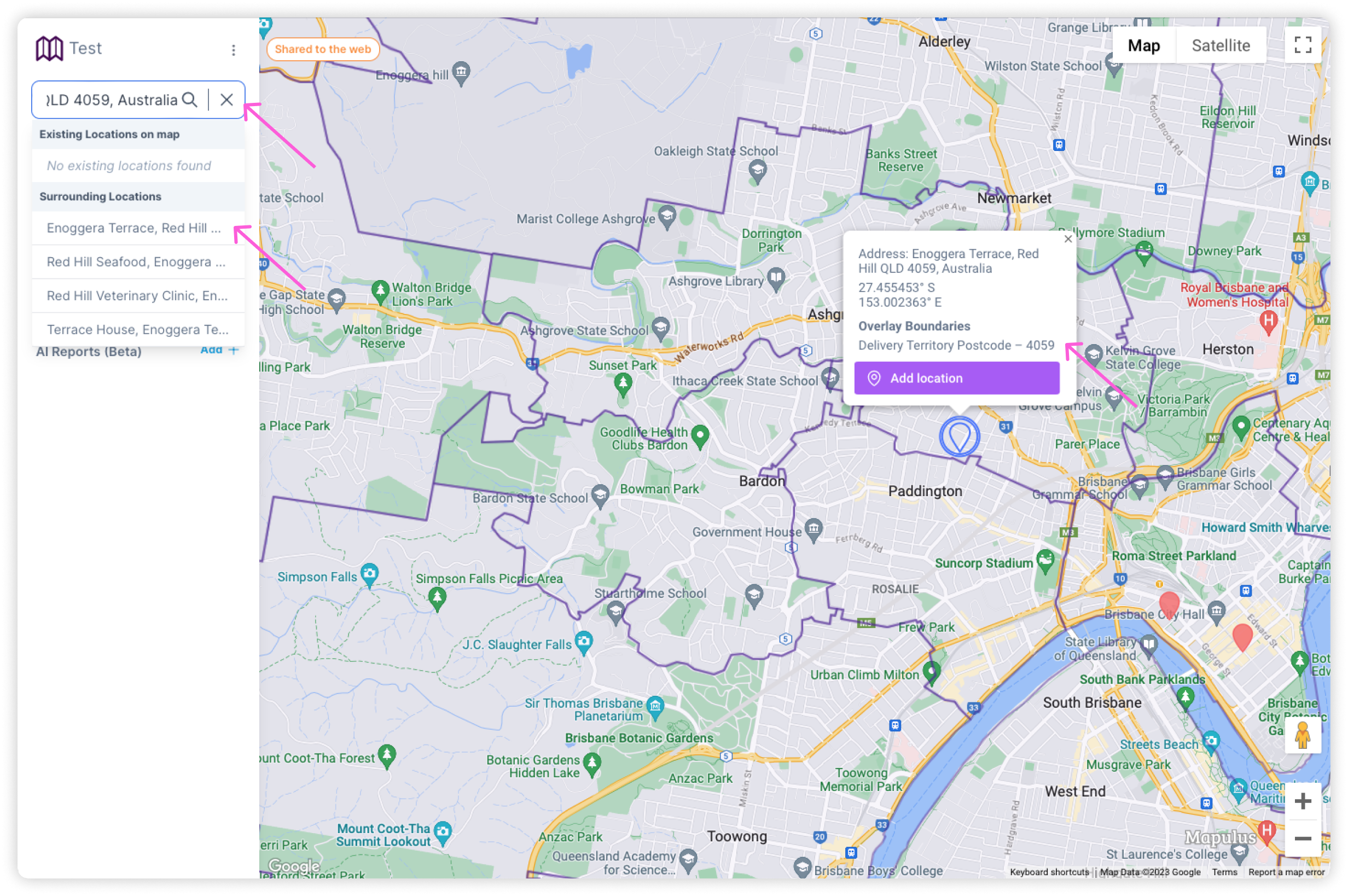
- Open a Mapulus map and locate the search bar at the interface’s top left.
- Type in the address or location you are interested in and select the correct suggestion from the drop-down list that appears.
- The map will automatically zoom in to the selected location. A marker or temporary point will be placed at the searched address on the map.
- An information window will pop up, detailing all the boundaries that include the selected address or point. If no boundaries are defined for that location, no boundary details will show.
Identifying Boundaries through Map Right-Click
- Navigate within your Mapulus map to the general area of interest.
- Right-click on the specific location on the map where you wish to learn about surrounding boundaries.
- A temporary marker will appear upon right-clicking, and an information window will automatically open.
- This information window will display all the boundaries encompassing where you clicked. If no boundaries are defined for that location, then no boundary details will show.
For both address searching and right-clicking methods, the information provided will include the names and details of the boundaries, giving you instant insight into the location’s zoning, jurisdiction, or any other pertinent boundary information available on your Mapulus map layers.
Viewing Boundary Names for a Searched Address
Once you have the temporary point set by searching:
- Click directly on the temporary point or right-click to open the contextual menu.
- Choose the option to view boundary information from the menu (if available).
- An information window will pop up, detailing all the boundaries that include the selected address or point.
Utilising Temporary Points for Boundary Insights
- For Existing Points: If the temporary point already exists, clicking on it will bring up the boundary information in the information window.
- For New Searches: If no point is automatically created after searching for a location, right-click on the location to create a temporary point and follow the same steps to view the boundary information.
Tips for Effective Boundary Identification
- Accurate Address Input: Ensure the address is correctly entered for precise location identification.
- Layer Management: Ensure the appropriate boundary layers are active to view them in the information window.
- Information Window Use: The information window can be expanded or moved around to better view the boundary details.
Troubleshooting
- If the boundary information isn’t displaying, ensure the boundary layers are not hidden or overshadowed by other active layers.
- Ensure that the Mapulus map data includes the boundary information for the area of interest.
- For issues with address searches or boundary information display, reach out to Mapulus support for personalised assistance.
By leveraging Mapulus’s powerful search and interactive mapping capabilities, users can better comprehend the boundaries that define any searched location. This functionality is indispensable for professionals in real estate, urban planning, delivery services, and many other sectors requiring detailed geographic information at their fingertips.